Katthammarsvik-Herrvik

Monday 20 July 2009
We are still behind the fat wall in katthammarsvik in waiting of the high winds. In the morning, the wind is still blowing 8-12 ms but now from the NW. Lucky for us, since we are heading SE. We have a very well covered harbour within 7 NM from here, Herrvik. We decide to sail from here and find Herrvik.

It only took less than an hour to sail to Herrvik. A beatiful harbour with nice jetties. Well protected for the rising winds. We stay here and do our washes, fix some other stuff and Christina treats the skipper to the local feast meal; saffran pancakes… Hmmmm.
This is how it looked before we stuffed it down our mouths.

The nice jetties at the Harbour mouth of Herrvik, Gotland.

Fjaugen-Katthammarsvik

Sunday 19 July 2009
position 57* 45,65 N 018* 58,59 E

At around noon we sail southward to the fishing village of Katthammarsvik where they are supposed to sell fish and other good food. We have a near-gale warning coming over the radio. But as we sail off the weather is fair with low winds and good visibility. The wind dies down altogether so we have to start the engine after 1.5 hrs at sea. smiley
At a quarter past four in the afternoon local time we are at the seafood restaurant in Katthammarsvik. The pier is 6 m high and a lot of yachts are anchored all around the bay behind the pier. We walk a few km to the local grocery store to buy some fresh food. Buy some fish at the fish market and then scurry down to Isabell. The wind has picked up and is churning around pretty bad in the harbour. Isabell is all pressed up against the stone wall of the pire. Shit! With very much trouble we get out of the spot (no help from any of the other boaters that just stare. Hate when that happens. We sail to the other side of the wall and tie with all the mooring lines we have. A french yacht is also tied to this side of the pier. Some germans come and help us tie our mooring lines. The wall is so high that we have to use a home-made staircase to climb up and down to the deck. In the evening the winds are 10-12 ms from SW. Good we are behind this heavy wall. Let’s hope we get out of here tomorrow. Now we try to sleep with the winds howling in the rigging. Our flag has been blown to a shred. Goodnight.

Dreaming of travelling North

After having read “Alla sa att vi skulle dö” about a couple of young people from the northern parts of Sweden (Kalix and Kiruna) who sailed an Albin Vega around the world between 2007 and 2009, I started to look into the option to sail all the way north in the Baltic and Bay of Bothnia, to the most northern towns of Kemi (Finland) and Haparanda (Sweden). From Stockholm this would be more than 570 NM one-way. Could be fun to get up there again and enjoy 24-hour sunlight for a while. I also found some literature about the Swedish coast harbours in the book “Norrlandskust” by Kryssarklubben. I wil have to try an get hold of the nautical charts from the Finnish coast to the Bothnia Sea and Bay.

Here is a nice map of the route in dark blue!
We’ll see what happens with these dreams! And a detailed sea chart (498 NM)

Old and new

Here is the 12-year old cover of the lifebuoy (guess which one?) and a brand new one that I invested in after the old one sort of started to disintegrate… Let’s hope the new one lasts as long as the old one… they cost a minor fortune, just the cover of the buoy!

Also have done some repairs on the genua, that started to loosen in the lower seams. Nicely sown new seams and repaired the UV shielding blue cover with 4 cm ripstop tape.

Heavy weather and diving time

Saturday 18 July 2009
Wind 10-12 ms SW
position 57*45,51 N 018*58,42 E

The anchor is dragging due to the stony bottom and hard winds from the SW. We decide to go ashore on the island of Flaugen. There is an old loading dock by the abandoned mine on the island. When we start the engine, we notice that a line has gotten caught in the propeller. Shit! Nothing else to do than for the skipper to do his less favorit thing. Go snorkling under the boat and cut loose the line from the propeller shaft. There is a float (netmarker) on the line. Piece of old fishing equipment.

After a few dives down the line is cut into short pieces and the prop is loose. We raise the anchor and run over to the quay at the mine. There we tie in very proper for heavy weather. We are safe. Captain rows across to another island with the dinghy and builds a huge stone marker on the top of a hill. We see this marker the next day, when we sail out to sea.smiley

Fårösund – Flaugen

Friday 17 July 2009. We wake up to wonderful warm summer weather. Get ready to round the NE coast of Gotland. Now we are heading south again.

At 0800 UTC we are on our way. With 4-5 ms SW winds we have an average speed over ground of 4 knots. Nice summer pace, slow and nice. We have the bimini up over the cockpit, because the sun is hot!

Sadly enough the barometer is dropping, so this weather is not going to last. But after 5 hours of slow sailing we reach the inlet of Flaugen. A great place! Coming to the inlet, we had the current against the wind and this gave heavily choppy waves. So the last half hour Isabell got a good shakedown. Everything was out of place. But nothing broken.
We drop anchor in 3 m of water inside the island Flaugen in the shadow of mining spill mount on the island. The bottom is sandy and stony, mixed. Not the perfect anchoring ground but when the weather gets worse we intend to go ashore on the island and tie in to the old mining pier. Right now there are four other yachts lying there. So we are good here. We take the dinghy into the shore and go sightseeing. Wonderful vegetation. There is an old ruin from which I take nice pictures of Isabell through the empty window holes.

A new coating

And after removing all the old antifouling Isabell gets a new coating of paint on the underwater hull. First she is white, then grey, then green and the grey again, then green again, and ends up nice and red…

Lauterhorn – Fårösunds guestharbour

Lauterhorn, Thursday 16 July 2009.

In the morning we get ready to sail, but our anchor is stuck behind a big block of limestone. It takes us about 45 minutes to get it loose. We do that by swinging around it on the engine, dropping a second anchor and then winching in the anchor with one of the mains winches. The we run past the other anchor and get it aboard as well. The wind is 6-8 ms from the NW. Barometer has gone up a kouple of notches and we expect better weather. Yesterday was actually quite nice as well. We have little trouble getting into the Sound between the islands of Fårö and Gotland. We stop at a few sites along the way to do some touristing. Great place this is. We decide to stay here for a day and go into port at Fårösunds båtklubbs gästhamn that is anice and quiet guest harbour on the Gotland side of the sound, just past the ferry crossing between the islands. Not so far from the Eastern entrance of the Sound. We go shopping and enjoy the little sandy beach right by the harbour. We are now 173 NM from the start of the trip. Not so bad to have gotten this far and still have everything in good shape. Thankful! The picture is taken just after we enter into the sound between Fårö and Gotland.

Heading north to Fårö

Wednesday 15 July 2009
From Flundreviken harbour to Lauterhorn (Fårösund)

After visiting the beautiful wall enclosed city of Visby we set sail to the North. Along the coast of Gotland a shallow shelf runs about 200 – 300 m out from the shoreline. Outside the shelf the water becomes very deep >100 m, but on the shelf the depth is less than 6 m for the most. The currents with upwelling deep cold water often cause dense fog along the western Gotland shore. So we experience a very thick fog today. We have very low winds from the SW and slowly pace through the fog. At no more than a few hundred meters another yacht passes us running on the engine. Scary! They come from out of nowhere and disappear just as swiftly. After a few miles out we have reached clear weather, the sun comes out and is hot. We see a search and rescue helicopter searching for something (don´t know what). In the afternoon the wind dies out alltogether and we start the engine and run closer to shore to try and catch the sea-breeze. No luck! But at 1630 UTC wind comes back and we have it from the SE this time. After another two hours we reach lauterhorn harbour, which is packed with big yachts. So we find a small cove just SE of the harbour and drop anchor there. We are now at position 57*56,30 N 019*05,08 E.
Tomorrow we intend to go through the sound between Fårö and Gotland toward East. Hoping for good winds we fall asleep. Goodnight.

Gotland, here we come!

Monday 13 July 2009 Byxelkrok (Oland) – Visby (Gotland)
Ships position 0730 UTC
57*19.68N 017* 00.37E
The big day has come. We are going across to the island of Gotland today… Exciting. We get ready and sail at 0800 UTC. The wind is still slow, but should pick up some during this fine day. Sunny and clear visibility. Barometer slowly rising. What more can we wish for. Ok, to get to the other side maybe?

After two hours at sea, the wind gets a little better, between 5-6 ms. We average 4.7 knots SOG according to the log. Good enough. We see several large vessels in the shipping lane. But we have them on AIS and keep far away from the lanes. At lunchtime we cross a thick layer of algal soup, a token of the pollution in the Baltic. It looks bright yellow in the otherwhise grey green seawater.

At 1715 we get outside the port of Visby with heavy shipping traffic all aroud us. We nearly get run over by a large container vessel. As I call them on VHF they answer and notice us, a spot on the waves, nothing for them to just run across. But they let us off the hook and go around behind us, 150 m distant. Huge shadow tearing past.
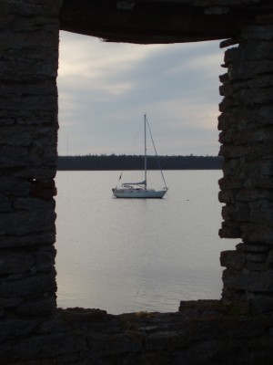
We have decided not to go into Visby, a big commersial marina, but look for a very small fishing harbour that we have seen in a book about Gotland (Gotland by Kryssarklubben). We finally find it and after some debate we slowly go through the very VERY narrow harbour entrance that luckily is well marked. But we are scraping the marking buoys on either side. The harbour is nice and almost empty, quiet and friendly. Flundraviken 57* 40.07N 018*19.50E. From here we have walking distance to the town Visby. Feels good to be here!